
Page 16 - Demo
P. 16
Navigointi, elektroniikka
GPS CHARTPLOTTER COMPATIBILITY GUIDE EMEA-APAC
del
PAGE 3 / 4
Model
Mo
Format
Blank (Downloadable)2
Blank (Downloadable)
Preloaded
ADVANCED FEATURES
SonarChartTM Live
S
Revised July 1, 2019. Check back frequently at navionics.com/compatibility.
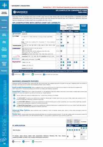
IMPORTANT: Always make sure your GPS chartplotter is updated with the latest firmware release from OEM for the best performance. IMPORTANT: Always make sure your GPS chartplotter is updated with the latest fi
Blank (Downloadable)
Preloaded
Preloaded
NAVIGOINTI / NAVIGATION
Revised July 1, 2019. Check back frequently at navionics.com/compatibility.
Revised July 1, 2019. Check back frequently at
6100i (requires S/W update 7.76); 6000i
CF CF CF CF
GPS CHARTPLOTTER C
Beginning in 2013, our products have come on 2 GB or larger memory cards. Always make sure your GPS chartplotter is compatible. Some GPS chartplotters may be compatible with 2 GB memory cards but may have difficulty with large file sizes. NOTE: Navionics+, Navionics+ Small and
Turvallisuus
Vesiurheilu
Köydet, kiinnitys
Ohjaus, hallinta
Vesi, wc, ilmanvaihto, polttoaine
Kansihelat, tarvikkeet
Mukavuus, suojaus, säilytys
Veneenhoito
Navionics Updates part numbers listed here are available only from a dealer.
GPS CHARTPLOTTERS WITH LIMITED CHART SIZE CAPABILITY
dealer
GPS CHARTPLOTTERS WITH LIMITED CHART SIZE CAPABILITY
MSD/DWL002
CF/DWL001
CF/NAV+NU CF/NAVU-NU
Blank
Format (Downloadable)2 (Download
Blank
NavNet VX2 SD/MSD
11 C Net; 11 C; 7 Wide, Wide Net; 5 Touring; 4 Gipsy, Gipsy NMEA CF
3; 3S SD/MSD
Multy; 11 Flash, Sun, Sunshine; 10 C; 8 Sunshine; 7 C; 6 Sun, Sunshine; 5
C; 4 CXS, C CF
768, 581i, 581, 580i, 580, 398ci SI, 386ci, 386ci DI, 385ci, 385ci DI, 365i, SD/MSD 365
Elite 4, 4DS, 4m, 4m HD, 5, 5 DSI, 5m, 5m HD;
Mark 4 (MicroSD only);
LMS 527c df iGPS, 525c df, 522c IceMachine, 522c iGPS, 520c; SD/MSD LCX 113c HD, 112c, 37c, 28c HD, 27c ;
GlobalMap 9300, 9200, 8300, 8200, 7300, 7200, 5300, 5200, 5150
PowerView 1200, 1100, 780B, 780, 485; HelmView HV1000i, HV450 SD/MSD
S S S S
S
S S S S S
E Series E120, E80
C Series C120; C80; C70
Raychart 400, 435, 435i
SonarChartTM
GPS CHARTPLOTTER COMPATIBILITY GUIDE
rmware release from OEM for
Nautical Chart
Community Edits
S
with Digital Yacht Sonar Server
S EMEA-APAC PAGE 4 / 4
NAVIONICS ADVANCED FEATURES
1
Advanced features are available when using a card that has an active daily chart updates subscription (included for one year if registered within two months of purchase). Also make sure your plotter has an updated software version installed.
Dock-to-dock Autorouting creates a suggested route, from a real start point to a real end point, based on chart data and navigation aids. NOTE: Autorouting is for planning purposes only and does not replace safe navigation operations.
SonarChartTM Live allows you to create new personal 1-ft HD bathymetry maps that display in real time on your plotter or mobile device screen while navigating. The new chart resides on your device for private use. Possible methods:
P Use your plotter with a sonar to enable SonarChartTM Live and see it directly on the display.
W Use built-in Wi-Fi® to connect your plotter/sonar to Navionics Boating app to enable SonarChart Live on your mobile. Depth data collected can also
be sent automatically to Navionics to enhance SonarChart.
G Use GoFree WIFI-1 Module to connect your plotter/sonar to Navionics Boating app to enable SonarChart Live on your mobile. Depth data collected can also be sent automatically to Navionics to enhance SonarChart.
S Use Digital Yacht Sonar Server to connect your plotter/sonar to Navionics Boating app to enable SonarChart Live on your mobile. Depth data collected can also be sent automatically to Navionics to enhance SonarChart.
Advanced Map Options gives customized views of Navionics charts to highlight shallow areas, target a fishing range and adjust SonarChart contour density.
Plotter Sync connects plotter and mobile wirelessly and allows you to transfer routes and markers. You can also update charts and activate or renew the subscription of your eligible plotter card. With Raymarine models, it is also possible to upload sonar logs to enhance SonarChart.
PC APPLICATION
TMQ C-Plot Nav+
Limited Platinum+ compatibility. Check with manufacturer.
Limited Platinum+ compatibility. Check with manufacturer.
1
CT Systems, Delius Klasing, Digital Yacht SmarterTrack, Elettronica Marittima, ENL, Eole, Euronav, NavigationPLANNER, PC Plotter, P-Sea, ScanNav, TIKI Navigator, Yachtcontrol
Nautical Chart SonarChartTM Community Edits
16
Marine Varusteet & Tarvikkeet
